Close Menu
    Facebook X (Twitter) Instagram
    Trending
    • Court Orders Police, IGP, Others Against Inviting, Arrest Of Action Alliance National Chair, Chief Barrister Kenneth Udeze, Party Leadership
    • NEMA Conducts Flood Simulation Exercise In High-Risk Riverine Dukku Community In Kebbi State
    • At NCC’s National Broadband Mapping System In Abuja
    • IGP Acquires State-of-the-art Equipment For Nigeria Police Technical Intelligence Unit
    • ‘No Officer Should Fight For A Nation By Day And Sleep In Indignity By Night’, IGP Says, Commissions Housing Projects In Kano State
    • NYSC DG To Passing-Out 2024 Batch ‘B’ Stream Two Corpers: Embrace Challenges, Lead Nigeria With Innovative Ideas
    • ‎Nigeria Police Force Cautions Against Lobbying For Special Promotion
    • Dangote Wins: ‘Cement Company Of The Year’ Award At Africa Housing Show
    Facebook X (Twitter) Instagram YouTube
    HumsimediaHumsimedia
    • Home
    • News
      • News Analysis
      • Politics
      • Environment
      • Energy
      • Security
      • Defence
    • Entertainment
    • Business
      • Economy
    • Health
    • Interview
    • Lifestyle
    • Global News
    HumsimediaHumsimedia
    Home»News Analysis»Enhancing Disaster Mgt In Nigeria: Significance Of The Newly Commissioned NEMA Geospatial Center
    News Analysis

    Enhancing Disaster Mgt In Nigeria: Significance Of The Newly Commissioned NEMA Geospatial Center

    HumsiBy HumsiFebruary 29, 2024No Comments3 Mins Read
    Share
    Facebook Twitter LinkedIn Pinterest Email

    By Abdulkadir Ibrahim

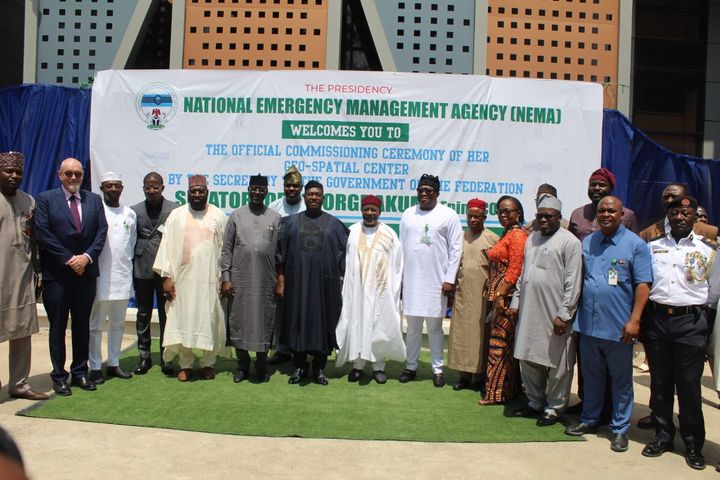
    In a world prone to various natural and man-made disasters, the role of effective disaster management cannot be overstated. For Nigeria, a country susceptible to a range of hazards such as floods, droughts, and epidemics, the recent commissioning of the National Emergency Management Agency (NEMA) Geospatial Center by the Secretary of The Government of the Federation Senator George Akume under the leadership of the Director General Mustapha Habib Ahmed marks a significant step forward in fortifying the nation’s disaster response capabilities.

    The NEMA Geospatial Center was established with the vision to leverage cutting-edge geospatial technologies in disaster management.

    This state-of-the-art center integrates Geographic Information System (GIS), remote sensing, and satellite imagery to enhance situational awareness, preparedness, and response strategies.

    Key Features and Capabilities:

    1. **Real-time Monitoring:** The Geospatial Center provides real-time monitoring of potential disaster hotspots.

    Through satellite imagery and GIS mapping, authorities can identify vulnerable areas and allocate resources proactively, minimizing response time during emergencies.

    2. **Risk Assessment and Mitigation:** The center facilitates comprehensive risk assessments, allowing authorities to identify potential hazards and vulnerabilities.

    This data-driven approach enables the formulation of targeted mitigation strategies to reduce the impact of disasters on communities.

    3. **Coordination and Communication:** Effective disaster management relies on seamless coordination and communication.

    The Geospatial Center acts as a hub for collating and disseminating critical information to relevant stakeholders, fostering a more coordinated and efficient response to emergencies.

    4. **Resource Allocation:** With geospatial data, decision-makers can optimize resource allocation by directing aid and relief efforts to areas most in need. This ensures a more equitable distribution of resources during crises.

    5. **Post-Disaster Recovery Planning:** Beyond immediate response, the Geospatial Center aids in long-term recovery planning.

    By analyzing the extent of damage and mapping affected areas, authorities can formulate sustainable rebuilding strategies and allocate resources strategically for reconstruction efforts.

    The Socio-Economic Impact:

    The establishment of the NEMA Geospatial Center is not just a technological milestone; it carries significant socio-economic implications for Nigeria.

    By enhancing disaster resilience, the center contributes to safeguarding lives, protecting infrastructure, and preserving livelihoods.

    This, in turn, fosters economic stability by minimizing the socio-economic disruptions caused by disasters.

    While the NEMA Geospatial Center represents a commendable stride in disaster management, challenges such as data security, infrastructure maintenance, and continuous skill development must be addressed.

    Furthermore, ongoing collaboration with international partners and leveraging emerging technologies will be essential to staying at the forefront of disaster management innovation.

    The commissioning of the NEMA Geospatial Center heralds a new era in Nigeria’s approach to disaster management.

    By harnessing the power of geospatial technologies, the nation is better equipped to face the complexities of an unpredictable world.

    As the center evolves and adapts to emerging challenges, it stands as a testament to Nigeria’s commitment to safeguarding its citizens and building a resilient and disaster-ready nation.

    Press unit
    NEMA Headquarters Abuja

    Geospatial Mustapha Habib Ahmed NEMA Senator George Akume
    Share. Facebook Twitter Pinterest LinkedIn WhatsApp Reddit Tumblr Email
    Humsi
    • Website

    Related Posts

    NEMA Conducts Flood Simulation Exercise In High-Risk Riverine Dukku Community In Kebbi State

    August 8, 2025

    2025 Flood Response:NEMA DG Makes Presentation To National Economic Council Meeting, Secures N10Bn Funding

    August 1, 2025

    NEMA Urgently Responds To Flash Floods In Maiduguri, Jere LGAs

    July 31, 2025
    Leave A Reply Cancel Reply

    Recent Posts
    • Court Orders Police, IGP, Others Against Inviting, Arrest Of Action Alliance National Chair, Chief Barrister Kenneth Udeze, Party Leadership
    • NEMA Conducts Flood Simulation Exercise In High-Risk Riverine Dukku Community In Kebbi State
    • At NCC’s National Broadband Mapping System In Abuja
    • IGP Acquires State-of-the-art Equipment For Nigeria Police Technical Intelligence Unit
    • ‘No Officer Should Fight For A Nation By Day And Sleep In Indignity By Night’, IGP Says, Commissions Housing Projects In Kano State
    Facebook X (Twitter) Instagram Pinterest
    © 2025 Humsimedia. Designed by Humsi Media.

    Type above and press Enter to search. Press Esc to cancel.

    • find-solution-system-equations-3xy20-3x3y30
    • read-excerpt-great-gatsbymy-house-eyesore-small-eyesore
    • read-excerpt-dangerous-gameby-richard-connellhe
    • read-paragraphmusic-important-element-students
    • read-excerpt-narrative-life-frederickdouglassin-book-i
    • neighborhood-homes-hit-manner-debris-windows-blown
    • way-babysitting-job-mary-rode-bike-first-mile-stopped
    • sandra-quite-overwhelmed-final-exammany-test-questions
    • means-preserving-beautyaccording-lines-william
    • checking-box-privacy-policy-page-company-legally-use
    • sentences-list-correctly-punctuatedif-go-mall-arrive
    • read-excerpt-chapter-2-nightit-took-us-long-time-recover
    • gateway-drug-dangerous-explain-several-sentences
    • information-literacy-happena-continuous-cycle-research
    • excerpt-act-v-scene-iii-romeo-juliet-best-reflects-idea
    • read-excerpt-enigma-machineat-bletchley-park-main-site
    • language-normans-old-norsetruefalse
    • read-excerpts-royal-house-thebesand-storyof-warrior
    • match-type-assessment-purpose-drag-assessment-correct
    • read-sentencei-need-stop-bank-grocery-store